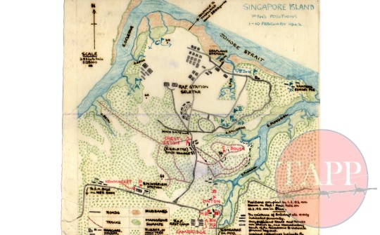
Sketch Map showing Cambridgeshire Positions at Seletar p.63
Item Information:
Catalogue Number: Moore Collection 001 Source: The Moore Papers Location: Seletar Airfield Report No: N/A Artifact Type: Map Production Date: 1942-10-02 00:00:00 Dimensions of Item: 22.5 cm x 23.5 cm Copyright with The Adam Park Project
Other Description:
The map was handrawn by Sgt Moore during his time of recuperation in Changi after the fall of Singapore. The map drawn in colour crayons on a single piece of paper 23.5cm x 22.5cm shows the disposition of the Cambridgeshire on the 1st February 1942 and on the 10th February 1942. The map shows in detail the geography of the Seletar peninsula in particular the forests, plantations, swamps and shoreline. The airfield buildings are also clearly marked. The location of each company is marked and colour coded. The positions held on the 1st February are in red and the positions taken over on the 10th February in blue. Notably the positions are named after towns in Cambridgeshire
Historic Context:
The Cambridgeshires were asked to initially hold the ground to the south of Seletar and support Indian army units manning the airfield perimeter but on closer inspection it was apparent the Indian troops were incapable of defending the shore line and buildings and the battalion under the force name of 'Cecil' were sent into the station where they remained until the 10th February. The battalion was then moved to Thomson Village before finally arriving at Adam Park on the 12th February


Comment Here:
Your email will not be published. Required fields are marked *