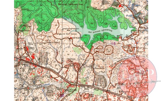
1938 OS map of Adam Park and immediate area
Item Information:
Catalogue Number: Map 001 Source: National Library of Australia Location: Bukit Timah Report No: Not Applicable Artifact Type: Map Production Date: 2015-11-25 00:00:00 Dimensions of Item: Copyright with Source Institution
Other Description:
A close up of a 1938 OS map of Singapore detailing the area immediately in the vicinity of Adam Park. The image shows the terrain from Bukit Tingii in the west to Mount Pleasant in the east and covers all the main features detailed in the battle reports and diaries.
Historic Context:
The battle for Adam Park was not confined to the immediate vicinity of the estate. The 1938 OS map was used by both sides in the conflict and many of the notable features get their name from the OS nomenclature and markings. Various hills in the area are named in accounts after the spot heights shown on the maps. The later 1942 copied of the map were of poorer quality and definition and there by harder to read. They were also reprinted using the earlier survey and therefore omit more recent changes to the landscape.


Comment Here:
Your email will not be published. Required fields are marked *
Related Items:
1st Battalion Cambridgeshires War Diary 1st to 15th February 1942
The Moore Papers
Sketch Map showing Cambridgeshire Positions at Seletar p.63
The Moore Papers